
From Tanks to Lakes
Atop a ridge at the southeastern edge of the Mysore Plateau (part of the Deccan Plateau) lies a not-so-small town called Bengaluru. This “town” is more of a megacity now with over 16 million people but the nostalgia for its early days is baked into every conversation I had, especially when it had anything to do with its “lakes”.

Pennar and Cauvery Basin flowing into the Bay of Bengal — Data from HydroSheds, Global Water Occurrence, KGIS, and OpenData.
Benjamin Heyne, the surgeon-naturalist who in 1800 took over the Sultan’s garden known today as "Lalbagh, [noted in his report to Colin Mackenzie,] “Lakes, in the right sense of the word, have nowhere been observed by me in this country but tanks or water reservoirs with artificial embankments are in great abundance.” — Except from p. 95, Tanks, in Deccan Traverses by Anuradha Mathur and Dilip da Cunha
The “lakes” as we know them now were technically “tanks” or “keres” in Kannada which were constructed by various communities including the Gangas, the Cholas, and the Hoysalas over the past 2000 years to help support the growing population for drinking water and crop irrigation. In the late 1500s, Kempegowda continued the tradition of transforming the undulating surface of water-holding systems as he introduced the expansion of the urban fabric. Within each of these communities, there was a keen understanding of natural hydrology where the bunds were built at the low point of the terrain to create a damming structure called a “bund” that held back the valley’s flow to preserve it for the dry season. During monsoons, these carved spaces in the earth would fill and the overflowing waters would cascade to the tanks within the series and then into the valley. This highly engineered system allowed the city to survive over 100km away from the nearest freshwater source, the Cauvery River which is also nearly 600m below the city.

WATER RESOURCE MANAGEMENT PLAN FOR THE CITY OF BANGALORE (LINK) by Mr. S Krishnappa, Engineer IN Chief Bangalore Water Supply and Sewerage Board (BWSSB)

The cascading tank system is currently regulated by a series of actors including the Bangalore Water, Sewerage, and Sanitation Board (BWSSB), the Bruhat Bengaluru Mahanagara Palike (BBMP), Bangalore Development Authority (BDA), and the Lake Development Authority (LDA) which likely contributes to the difficulty of managing and integrating them into a comprehensive hydrological infrastructure system. The management requires a comprehensive understanding of meteorology, hydrology, and hydrogeology because when the rains do come, the gates must be opened to let the water flow into the lower tanks in the system. The last decade has brought increasingly sporadic rainfall and even “cloudbursts” making it nearly impossible to prepare this hydrological landscape for the rains. The news is filled with images of waist-deep waters flowing through the streets and submerged houses throughout the eastern side of the city.

Global Water Occurrence — Global Surface Water Explorer, via https://global-surface-water.appspot.com
The water bodies have all but disappeared turning into airports, golf courses, IT parks, and developments. In the image above which describes the Global Water Occurrence, you can see the dammed landscape of the Cauvery river tracking at the bottom and the series of gradient dots showing the tank system of the region.
Tanks to “Lakes”

Agara Lake, Photograph by Amanda Gann in May 2022
In their early days, each tank was collectively cared for and used by the adjacent villages and it was imperative that they work together to keep it in working order. Since the introduction of piped water, the tanks fell into disrepair in the latter half of the 20th century. In the last 20 years, in the name of restoration, these tanks have transformed into pools of treated wastewater surrounded by elevated paths, workout equipment, and ornamental trees where walkers come early and late to encircle the waters enjoying the peaceful tranquility away from the bustling streets.
These fenced spaces once invited community members to engage with its waters to wash clothes, fish, graze their cattle, and collect grasses, fruits, and seeds. In the last century, as the city has grown from a town to a megacity, the relationship with these water bodies has drastically changed.
As the relationship with the tanks changed over time, the terminology used changed as well. In the early 1900s, the tank systems started to be called “lakes” and as the restoration projects continued into the early 21st century, the term “lakes” became more widely used. No longer used for drinking water or irrigation (in the city at least), the term “tank” didn’t make much sense. Interestingly, the seasonality of the “tank” went with the word. Now filled year-round with treated wastewater, the ephemerality of these waters has ceased lending it to a static “beauty” that can no longer hold the amount of rainwater it was designed to hold which means that the city’s lowlands and streets become the new rivers during the rainy season.
Historical Depictions of the cascading tank system
In the late 1700s, the surface of the earth was surveyed and documented showing over 1100 water bodies that provided water for mostly irrigation to the villages spread across the countryside. Forts at the Pettah, Hoskote (Hosacotta), Hosur (Hosoor), and Anekal (Anicull) connected by paths through the undulating “maidan” as it was called. The eastern side of the city was mostly used for agriculture as the landscape cascaded a bit more gradually than the west side of the city which quickly declined into the Arkavathi and Vrishabavathi valleys. The maidan was home to many tanks bunded and encircled with trees to demark its edges. The 1806 map drawn by the British depicts the network of tanks that served as life sources for the communities and as a defense landscape for any intruders.
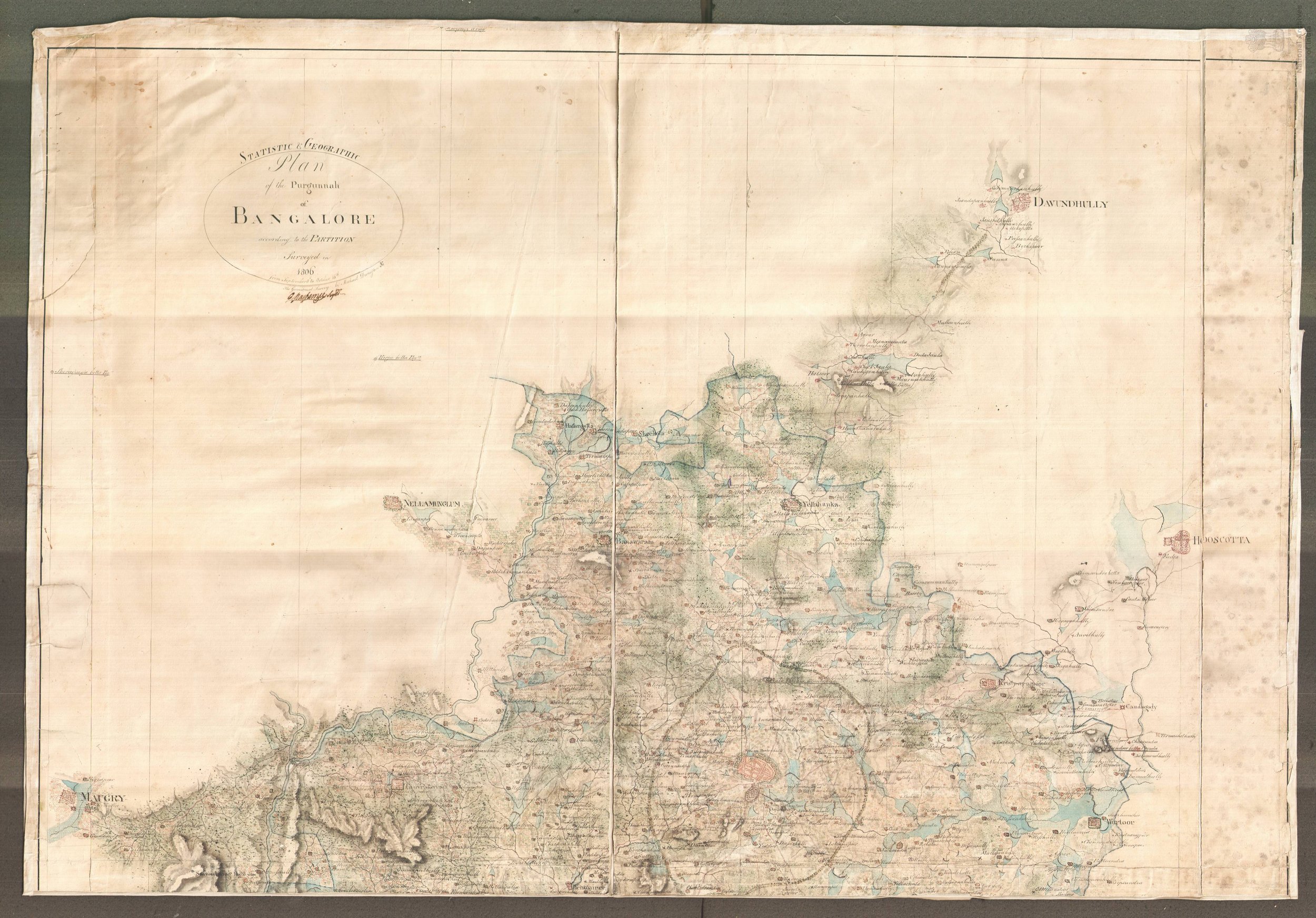

Statistical and Geographic Plan of the Purgunnah of Bangalore in 1806, courtesy the National Archives in New Delhi, India
Throughout the landscape even into what is now considered “peri-urban” Bengaluru, the tanks were documented to show their edges and how they interfaced with development and roadways. Upon seeing this map, I wondered if there was a potential to learn from this system that had so carefully been developed and how we might incorporate these ideas into the development of the peri-urban region. Could we build in space for the water-holding systems and make them multifunctional infrastructure? Could we make parks that hold water during the monsoon and then serve as public space during the rest of the months? What is the potential within roadways? Could we design them differently to capture, treat, and convey water to local holding tanks or into recharge wells that replenish the shallow aquifer? I believe yes.
Now onto the design testing phase! ~~~~